URGENT: Please send an email to the minister before Monday 15th Aug
You can send him a second or even third letter
use the form below
You can send him a second or even third letter
use the form below
At the last meeting in a process to determine the development proposal for Clump Point, the independent facilitator Simon McNeilage, encouraged feedback from our groups adding that the Minister wants hear from the Mission Beach community. Below is a considered position based on the information and outcomes of the meetings so far to provide practical and environmentally sustainable solutions to service both commercial and recreational boating needs at Mission Beach.
This is the last chance to let the minister know you support development that will have no adverse impact on the World Heritage values of Mission Beach.
This is the last chance to let the minister know you support development that will have no adverse impact on the World Heritage values of Mission Beach.

Hon Dr Anthony Lynham
|
A change in tack for boating infrastructure project at Mission Beach
Just when we thought the final decision on the design of the Mission Beach Safe Boating Infrastructure Project had been made, the whole plan was turned on its head after the minister for State Development, Dr Anthony Lynham, visited Mission Beach in January 2016. The boat ramp component of the development had been approved, tendering process started and the rock wall breakwater at the jetty was under assessment by GBRMPA. The proposed development which had taken three years of community involvement/feedback, numerous visits by State Government representatives and $1.8m spent by consultants, was brought to a halt with the minister deciding the whole project was to be transferred to the Clump Point boat ramp. |
|
Expanding boating infrastructure at Clump Point has been a 30 year long community dividing issue. The main point of contention in community vision is development to include permanent berths (a marina). The recreational boating reserve at Clump Point has very limited shelter, is on an open lee shore on a cyclone exposed coast and is mapped as a Habitat Protection Marine Park Zone. The headland scenic and recreational reserve is mapped as an area of high ecological significance.
|
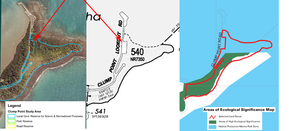
Click to enlarge
|
|
The process starts all over again
An independent facilitator has been engaged by the State Government to lead a new reference group comprising representatives from the community. Three meetings have been held so far, including on site. The process is to identify the possibilities and constraints of concentrating the whole of the boating infrastructure on the Clump Point headland.
The surveys have revealed a high biodiversity fringing reef surrounding Clump Point and presence of sparse sea grass ( the preferred food of the highly selective endangered dugong. They graphically show the impact siltation and existing development has had on the reef to the western side of the boat ramp. (see icons right)
The latest design produced by the Transport and Main Roads includes expanded boat ramp to three ramps and extra landing, extra car parking, a jetty separating a new 120 metre rock wall from the existing rock wall with a 70 metre landing pontoon and room behind the rock wall extension for 5 pylon 'pens' for permanent berths. (See Latest TMR concept icon right)
Importantly, it has be clarified that the new Perry Harvey Jetty has the same depth of water and usability as the old jetty, has fresh water facilities and is available for permitted refueling. (see Jetty depths right)' The Hydrology reports and draft development plan have yet to be presented. |
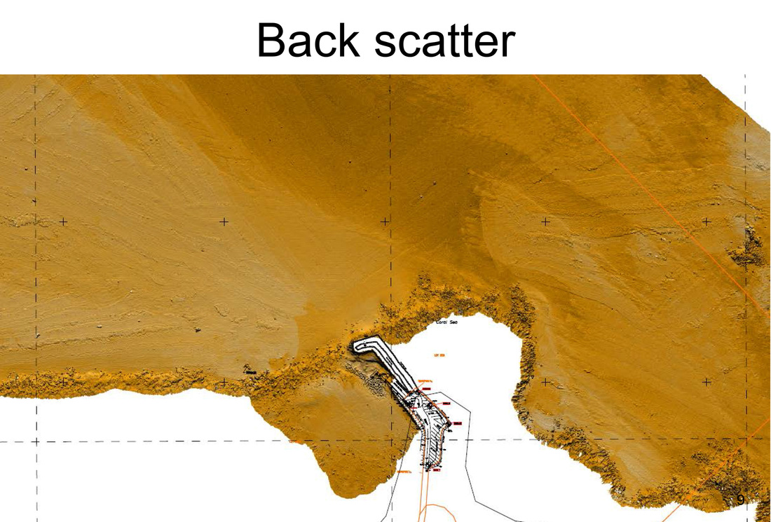
Sea bed imagery
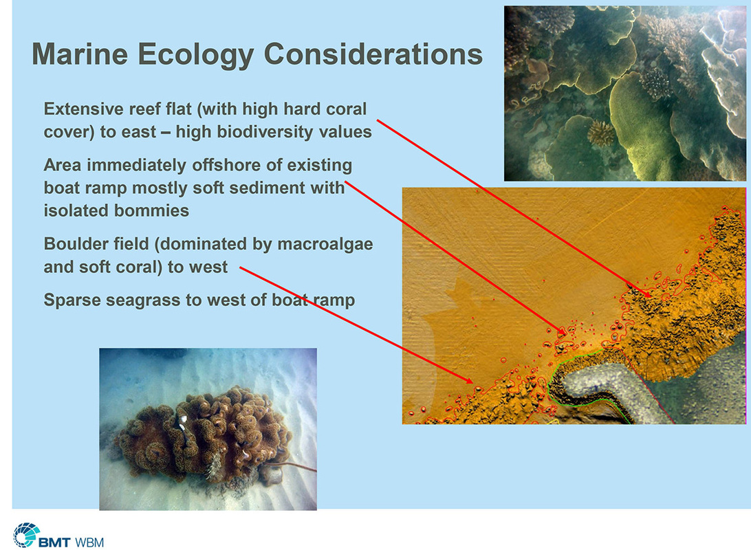
Fringing reef
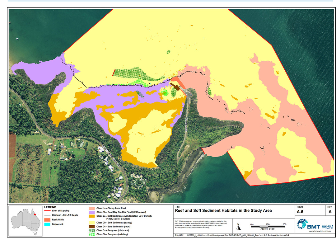
Marine habitats

Latest TMR concept
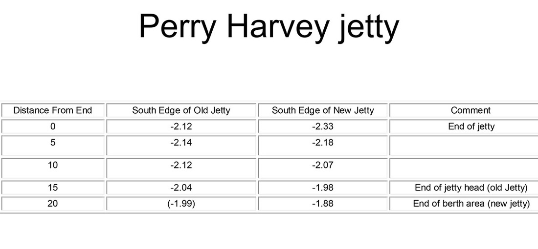
Jetty depths
|
Copy and paste the text (below left) into the box (right) to send the Hon Dr Anthony Lynham a clear message from the Mission Beach community. (You can change or alter the message, it has more impact if you use your own words).
|
I share a vision for Mission Beach of a thriving nature based tourism economy based on protection of the exceptional natural and cultural values of our two World Heritage Areas: i e low key and boutique in nature.
Clump Point is a unique and iconic headland able to be enjoyed by the whole Mission Beach community. Providing marine facilities at this location has resulted in destruction and ongoing impact of a section of fringing reef for a boat ramp, and recent destruction of critically endangered rainforest mapped as essential cassowary habitat, to provide extra recreational boating car parking as part of the State Development 'Safe Boating Infrastructure' project. In the interest of retaining the natural character of Mission Beach, consistent with the above vision and the World Heritage convention, future development must strive for ‘no adverse impact’. Re the Safe Boating Infrastructure Project being planned within both the recreational boating and scenic reserves at Clump Point I support the following: - the Perry Harvey Jetty to be included in the provision of safe boating infrastructure, - fuel provision at the Perry Harvey Jetty only, not at Clump Point, - a landing for safe loading and unloading of passengers and goods at those times when boating is possible (that is weather permitting), - car park areas to include permeable surfaces and native shade trees appropriate to this high-value natural setting, - a “Whole of Clump Point Management Plan” to protect the high environmental and cultural values and wilderness character of the headland, - upgrade of boat ramp to three ramps with extra landing, - If a rock wall is to be constructed: that the rock be transported by barge only, to avoid impact of heavy vehicle traffic on roads, community and cassowary habitat. I do not support: - barge landing at Clump Point, - wash down facilities on the headland, - permanent berths, introduction of floating pontoons (marina), future expansion or private development, I have serious concerns about: -the purpose and footprint of a rock wall (proposed 120 metres) and its impacts on the natural values of Clump Point including its fringing coral reef, its unique geomorphological form and its beauty. |
|