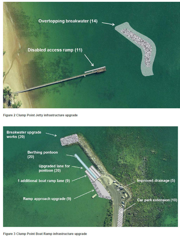
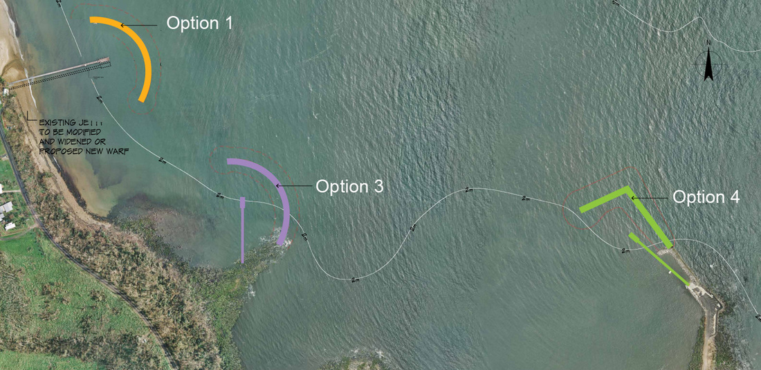
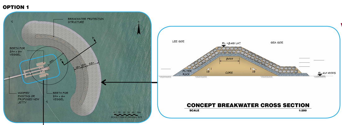
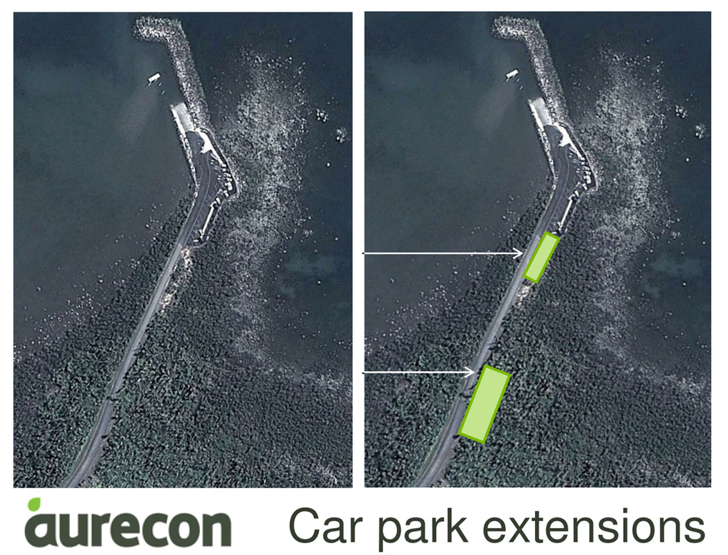
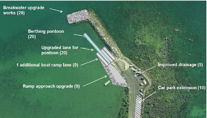
| On 29th November 2013 at the Mission Beach Resort, Aurecon gave a presentation to invited stakeholders outlining the process to decide the designs for the 'Safe boating infrastructure Project' at Clump Point. Of the 20 options considered in the Multi Criteria Analysis (MCA) a rock wall island breakwater at the head of the jetty and an upgrade of the existing Clump Point boat ramp (left) were promoted as the best solutions to their brief in the Invitation to Offer (ITO) The following is the considered response to Aurecon's recommendations by the Cassowary Coast Alliance (CCA) CCA supports the decision to provide facilities for berthing only, with no mooring of marine vessels, and choosing the low key option to provide safer boating at the boat ramp. CCA does not support the addition of a rock wall breakwater in an attempt to provide calm water at the jetty. |
The provision of an extra boat ramp and upgraded landing facilities to cater for commercial operators when conditions are unfavourable at the jetty appears a practical and appropriate solution; one which is likely to reduce user conflict on those rare days when demand for the facility creates congestion.
The upgrade of the boat ramp (as outlined in Aurecon's report) may be the best solution for the long term recreational boating needs of the small Mission Beach community.
The upgrade of the boat ramp (as outlined in Aurecon's report) may be the best solution for the long term recreational boating needs of the small Mission Beach community.
COMMENTS
(1) the island rock wall proposal (jetty area)
(1) the island rock wall proposal (jetty area)
| Concerns regarding a breakwater at the jetty were outlined during the consultation process and are well recorded in this report when the option was presented by GHD consultants in Dec 2011. Just like the shore itself, the jetty is fully exposed to storm winds and seas, seasonal prevailing south-easterlies and afternoon (north-easterly) sea breezes. It would be unrealistic to expect that any modifications to the jetty would make a critical difference in convenience of landing ("increased safety for loading and landing of passengers during ambient conditions") on more than a limited number of additional days compared with the present. Construction and environmental costs need to weighed against the hoped-for added convenience and commercial profitability. |
If there had been a simple solution it would have been adopted years ago. Attempting to provide calm water with an artificial rock sea wall at a jetty on a cyclone exposed coastline, apart from the anticipated sedimentation, will have limited success and encourage expectation for permanent mooring.
| The proposed development would dominate the land and seascape, changing its character and damaging its world heritage environmental and aesthetic values; all for little, if any, real advantage. It would, for example, detract from the scenic tourist walk planned as part of Mission Beach Tourism's 'Turning of the Tide' project. |
Local and state planning schemes covering the Mission Beach coastline highlight the high scenic value and recommend it be maintained having the appearance of an undeveloped shore. Clump Point/Bingil Bay is particularly singled out as a key coastal site in the Wet Tropics Tropical Coastal Management Plan.
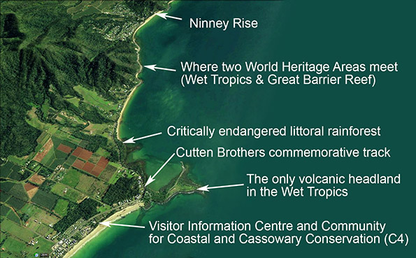
The Clump Point Jetty location is the gateway between two world heritage areas; it lies within the Great Barrier Reef Coastal Marine Park; and is a designated coastal habitat conservation zone. A large artificial structure such as a rock wall is an unavoidably obvious and ugly intrusion which can only dominate the experience of visitors using the jetty to visit the Great Barrier Reef.
The exceptional scenic, heritage, cultural, and unique geological values of the Clump Point headland are long term economic assets. It doesn't make any sense to compromise them for unconfirmed short term purposes.
The Clump Point Jetty location is the gateway between two world heritage areas; it lies within the Great Barrier Reef Coastal Marine Park; and is a designated coastal habitat conservation zone.
A large artificial structure such as a rock wall is an unavoidably obvious and ugly intrusion which can only dominate the experience of visitors using the jetty to visit the Great Barrier Reef.
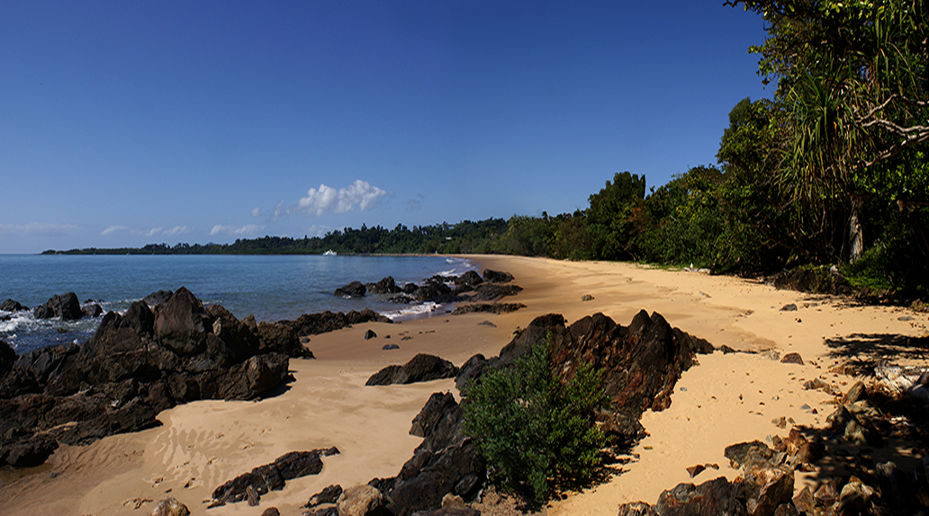
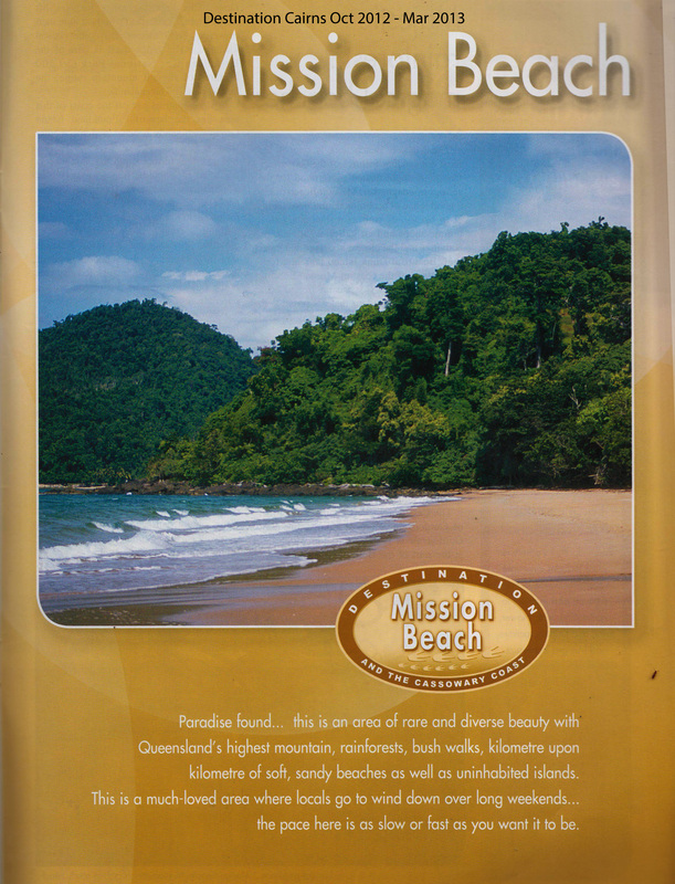
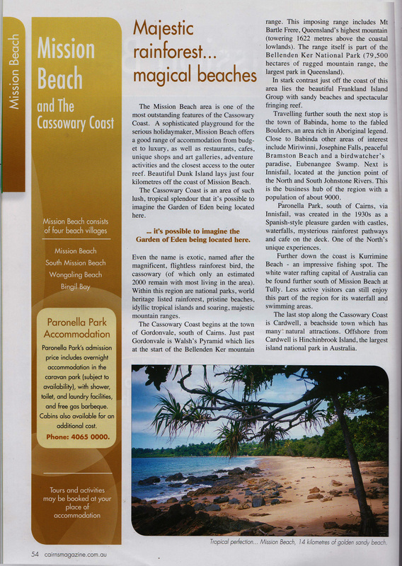
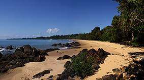
| The incremental loss of the natural appeal through the lack of adherence to planning schemes, ad hoc and inappropriate development, exacerbated by major cyclonic events has been identified by the recently formed community Visual Amenity Reference Group (VARG), as contributing to a decline in community sense of place and tourist appeal. The built environment is beginning to dominate the natural environment at Mission Beach, a place where the tourism economy is reliant on protection of the outstanding natural values. It is inconsistent with the image being promoted to attract tourists to our area. | Above; Tourist promotion booklet 'Destination Cairns' Oct 2012/Mar2013. Above right; Narragon Beach described as 'tropical perfection'. |
(2) the Clump Point boat ramp and area
| CCA supports restoration of historically degraded natural areas as an offset for environmental losses caused by other elements of the proposed upgrade. Proposals for the Clump Point boat ramp area will have quite an impact on the high scenic and world heritage aesthetic values and the local natural environment of Clump Point. Overall the proposal would involve considerable site hardening and other modifications, including clearing of protected native and other vegetation for vehicle parking. |
RELEVANT MATTERS NOT INCLUDED IN AURECON PRESENTATION
There were some omissions in the materials presented which are important given that this was a public presentation. These include:
- no overlay of Remnant vegetation. Although Regional Ecosystems are shown on the drawing (including critical habitat), smaller remnant patches are not shown on any drawings.
- no mention in 2.1 of the subject site being under Djiru native title in the outline of tenure encompassing Lot550 NR 7351, Lot 540 NR 7350);
- no evidence for effectiveness as described of the proposed measures;
- no assessment of potential environmental impacts on coastal processes including shoreline;
- no proposals for vegetation rehabilitation actions.
- no consideration for design option at jetty (included in the ITO).
NEW SUGGESTIONS
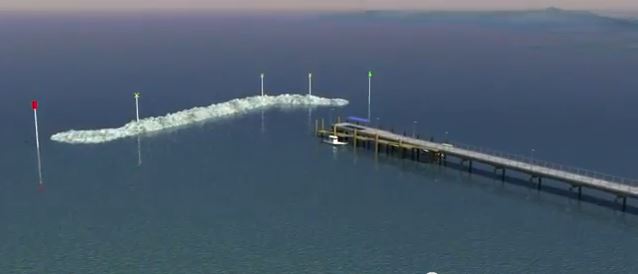
A new suggestion for wave calming at the jetty is to have additional staggered rows of large diameter piles underneath an extension to the jetty, which would have some wave breaking action and a relatively low impact on visual amenity. Several variations could be explored.
A new suggestion for wave calming at the jetty is to have additional staggered rows of large diameter piles underneath an extension to the jetty, which would have some wave breaking action and a relatively low impact on visual amenity. Several variations could be explored.
This array of staggered piles might quiet on-shore wave action enough to allow for a floating pontoon to be attached to the jetty, to be removed or submerged during cyclonic events. An appropriately sized shade at the end (similar to that shown above) would soften the heaviness of the array of piles.
Unless there are cogent engineering reasons against such a construction, an under-jetty staggered pile array should be assessed for its impacts on coastal processes and biodiversity in this GBR Coastal Marine Park Habitat Protection Zone, its effect on the jetty in strong weather, and its wave-calming effectiveness measured in additional days of safe landing.
Unless there are cogent engineering reasons against such a construction, an under-jetty staggered pile array should be assessed for its impacts on coastal processes and biodiversity in this GBR Coastal Marine Park Habitat Protection Zone, its effect on the jetty in strong weather, and its wave-calming effectiveness measured in additional days of safe landing.
Questions
1 (a). What evidence is there to support the statement by Aurecon engineer, Gildas Colleter that the new facility should cater for 4000 boats?
1 (b). What consideration has been given to the ongoing impact of extra traffic associated with extra boats and trailers travelling to Mission Beach on many kilometres of roads passing through cassowary habitat?
The total population of Mission Beach is around 2000 persons. It is unlikely that such a number of people from other locations would drive to Mission Beach when there exist satisfactory facilities at Hull Heads, Tully Heads, Kurramine, and Mourilyan Harbour (recently upgraded at a cost of $2m). If this reflects a desire to increase commercially advantageous visitation to Mission Beach it needs to be weighed against the preservation of the long term recreational amenity and existing local tourism use, and evidence provided to support this view.
1 (c). What consideration has been given to long convoys of heavy trucks loaded with rocks (to build the proposed island rock wall) that would need to travel through cassowary habitat?
Mission Beach supports the highest density of endangered cassowaries in Australia, is the icon of our region and a major tourism drawcard. Vehicle strike is the biggest threat to the endangered cassowary after habitat loss. All access roads to Mission Beach travel through cassowary habitat with hotspots where there have been multiple deaths.
2. What evidence is there that Aurecon's proposed island breakwater (near the jetty) will perform as described? We have received comments from two scientists who have expertise in a related field. We ask for your response to the following comments:
"The idea of an overtopping wave breakwater more-or-less in front of Clump Point jetty is a bad idea. Especially as no current/drift studies have ever been done for the area - or if they have been carried out they are not public or are very well-hidden. The time frame for the proposed work does not allow sufficient proper study to be done.. I have very recently seen wave-breakwaters along the coasts in cyclone-prone Okinawa (southern Japan) and they are placed much closer to the thing they are intended to protect (e.g. coast road, beach, houses) and are built higher and made of concrete tetrapods which break up the wave force better by their design and structure. Which makes them conspicuous and pretty ugly." (Scientist and local resident Dr Helen Larson)
3. Some comments received from long term residents and local boat operators (below). These comments reflect reasons other than a perceived lack of "safe landing" for the historical changes in commercial boating activity at Mission Beach.
4. What impacts will the proposed constructions have on the shoreline eg deposition, foreshore erosion/ beach recession, etc.? Can you provide maps showing likely changes to profiles following implementation of the works and following a category 3,4, or 5 cyclone?
5. Why was a widely community-supported option for wave-calming measures incorporated within an extension to the jetty was not among the 20 options included in Aurecon's MCA. It was the preferred option supported by a local commercial tourist boat operator, Friends of Boat Bay, Cassowary Coast Alliance and the Community for Coastal and Cassowary Conservation and was outlined at the stakeholders meeting held in March 2013. A version was included as an option in the ITO No. DSDIP-2127-13Mission Beach Safe Boating Infrastructure-Design Services. On the other hand, we fully understand, a T-section attached to the head of the jetty, incorporating suspended concrete walls as shown as option 1 in GHD 2011 presentation, would be visually very intrusive and would not withstand strong conditions.
6. Where are the results of the study to determine if and where boating infrastructure was appropriate along the Cassowary Coast ? This study was a requirement of the Qld Coastal Plan. $5.5m was allocated by the Federal government for a scoping study for safe boating facilities at Mission Beach which was never carried out.
1 (a). What evidence is there to support the statement by Aurecon engineer, Gildas Colleter that the new facility should cater for 4000 boats?
1 (b). What consideration has been given to the ongoing impact of extra traffic associated with extra boats and trailers travelling to Mission Beach on many kilometres of roads passing through cassowary habitat?
The total population of Mission Beach is around 2000 persons. It is unlikely that such a number of people from other locations would drive to Mission Beach when there exist satisfactory facilities at Hull Heads, Tully Heads, Kurramine, and Mourilyan Harbour (recently upgraded at a cost of $2m). If this reflects a desire to increase commercially advantageous visitation to Mission Beach it needs to be weighed against the preservation of the long term recreational amenity and existing local tourism use, and evidence provided to support this view.
1 (c). What consideration has been given to long convoys of heavy trucks loaded with rocks (to build the proposed island rock wall) that would need to travel through cassowary habitat?
Mission Beach supports the highest density of endangered cassowaries in Australia, is the icon of our region and a major tourism drawcard. Vehicle strike is the biggest threat to the endangered cassowary after habitat loss. All access roads to Mission Beach travel through cassowary habitat with hotspots where there have been multiple deaths.
2. What evidence is there that Aurecon's proposed island breakwater (near the jetty) will perform as described? We have received comments from two scientists who have expertise in a related field. We ask for your response to the following comments:
"The idea of an overtopping wave breakwater more-or-less in front of Clump Point jetty is a bad idea. Especially as no current/drift studies have ever been done for the area - or if they have been carried out they are not public or are very well-hidden. The time frame for the proposed work does not allow sufficient proper study to be done.. I have very recently seen wave-breakwaters along the coasts in cyclone-prone Okinawa (southern Japan) and they are placed much closer to the thing they are intended to protect (e.g. coast road, beach, houses) and are built higher and made of concrete tetrapods which break up the wave force better by their design and structure. Which makes them conspicuous and pretty ugly." (Scientist and local resident Dr Helen Larson)
- Ocean Scientist Daniel Atwater provided the following comments: "My hypothesis is that the proposed plan will end up costing the local shire council a lot of money via on-going maintenance costs once the positive sedimentation feedback loop dominates the breakwater plan."
- Further, the same oceanographer also noted that such a construction might not gain approval within the GBRWHA: "I was unable to find any other man-made breakwaters within the Great Barrier Reef Marine Park. So I believe this would be the first; something that the state and more so the federal government should not consider lightly".
3. Some comments received from long term residents and local boat operators (below). These comments reflect reasons other than a perceived lack of "safe landing" for the historical changes in commercial boating activity at Mission Beach.
- Inter-island ferries used to cater to guests of the Dunk Island Resort, which was closed after Cylone Yasi. It is not proposed to resume operation in the foreseeable future, its site now destined for other uses. The water taxis servicing Mission Beach to the islands were designed as beach landing craft. Beach landing craft, while suited to the Mission Beach setting, are not suitable for jetty-side loading under any circumstances.
- To quote a local resident, "I remember the old concrete jetty from the 80s, the timber one from the 90s and the bus loads of people using it for their GBR / island visitor experiences. Sure there are times when the jetty was unusable on big north-easterlies but how often do those happen? The big boats only left the area because of increased competition of the bigger faster boats operating from Cairns and Port Douglas - nothing to do with the jetty".
- Existing commercial boats have been using the boat ramp not only for its easier access but also to avoid jetty fees. The jetty would have been more accessible to the generally smaller commercial boats now working from Mission Beach had practical upgrades appropriate to the needs being considered during regular maintenance instead of being left to deteriorate (following cyclone damage) by decision of a past local Council. This decision reflected developer driven pressure for large scale marine infrastructure at Mission Beach.
- Rising fuel costs make it unlikely that an expansion of commercial marine businesses in the foreseeable future will rely on visitors travelling long distances to access the GBRWHA from Clump Point.
4. What impacts will the proposed constructions have on the shoreline eg deposition, foreshore erosion/ beach recession, etc.? Can you provide maps showing likely changes to profiles following implementation of the works and following a category 3,4, or 5 cyclone?
5. Why was a widely community-supported option for wave-calming measures incorporated within an extension to the jetty was not among the 20 options included in Aurecon's MCA. It was the preferred option supported by a local commercial tourist boat operator, Friends of Boat Bay, Cassowary Coast Alliance and the Community for Coastal and Cassowary Conservation and was outlined at the stakeholders meeting held in March 2013. A version was included as an option in the ITO No. DSDIP-2127-13Mission Beach Safe Boating Infrastructure-Design Services. On the other hand, we fully understand, a T-section attached to the head of the jetty, incorporating suspended concrete walls as shown as option 1 in GHD 2011 presentation, would be visually very intrusive and would not withstand strong conditions.
6. Where are the results of the study to determine if and where boating infrastructure was appropriate along the Cassowary Coast ? This study was a requirement of the Qld Coastal Plan. $5.5m was allocated by the Federal government for a scoping study for safe boating facilities at Mission Beach which was never carried out.






 RSS Feed